
Wet Boundary: How the Flint River Defined Atlanta
2021 marks an important anniversary for Atlanta. It’s been two hundred years since the 1821 Treaty of Indian Springs in which the Creek Nation ceded the territory that would become the capital city we know today. You could think of this year as the bicentennial of Terminus or Marthasville or metro Atlanta – the entire landscape where I spend most of my days.
How should we remember this anniversary? I assumed there would be memorials or retrospectives to mark the anniversary – some somber exhibition at the Atlanta History Center or a column in the AJC. But January 8, 2021 rolled by and I forgot about it. I was probably watching footage of the Capitol insurrection on my phone.
Even without multiple national crises to distract us, I’m not sure how Atlantans would have commemorated this event. I understand – vaguely – that some watershed moment happened in 1821. Whenever I’m researching the history of any Atlanta subject, from the development of the Atlanta Airport to my current work on a river restoration project called Finding the Flint, the timeline of Atlanta history begins at 1821. All paper trails lead back to the 1822 surveys and plat maps.
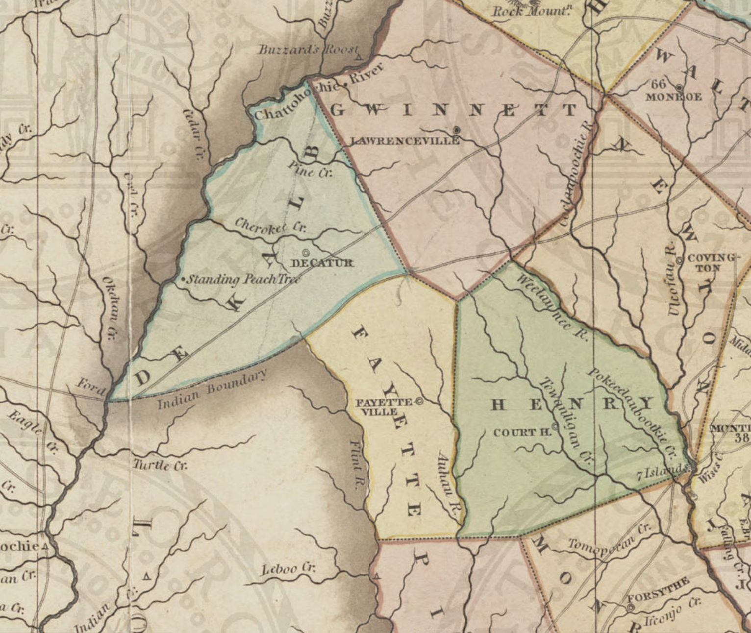
Upper Flint River & vicinity, 1823 (Engraved by H. S. Tanner; Source: Georgia Archives)
I often return to this simple but astounding online map that animates the formation of Georgia’s counties from colonial times to the present.1 It starts in 1758 with the Atlantic coast sketched out in parishes and the rest of the state represented in dotted gray – “Cherokee Lands” and “Creek Lands.” This blank frontier looks as if nothing existed; as if roads and cities and administrative districts needed organizing. As if it was pristine wilderness; a blank slate.
Hit play and watch Georgia’s counties march west year by year, river by river, the state chomping away jagged bites of gray. By 1837, the U.S. Army force-marched more than 20,000 Creek people from the Southeast.2 Today, there are no federally recognized tribes living in Georgia.
Somewhere in that timeline of turmoil and unraveling was the Treaty of Indian Springs, just one of a series of Indigenous land losses in Georgia. The 1821 cession shifted the border between Georgia and the Creek Nation from the Ocmulgee River to the Flint River, and opened up a nearly five-million-acre slice of land to hungry surveyors and land lottery settlers.
Muddying the waters, so to speak, was my own childhood experience at Indian Springs State Park. When I was growing up, it was a destination for outdoor family fun, like Stone Mountain. I visited Indian Springs on field trips and Girl Scout jamborees. I was taught that Chief William McIntosh signed the Treaty of Indian Springs, but none of the details. Not much was said about Indian removal; what happened before and after the treaty was another kind of blank space. Like Stone Mountain, I had a shallow concept of the place’s heroes and lessons.
And then there’s the Flint. For a brief moment in time, the Flint River was an international treaty boundary, another line in the sand. As someone who is actively working to restore the Flint River and repair its tarnished reputation in Atlanta, I’ve felt the need to understand the Treaty of Indian Springs. Two hundred years later, I wonder if the treaty represents just a legal hurdle or something essential about our city? The Flint River made Atlanta possible, but does it matter now?
The Treaty of Indian Spring haunts me, haunts our city, and we should grapple with it as honestly as we can.
The Springs
Thinking of the anniversary as a kind of teachable moment, this summer I took my family to Indian Springs State Park.
Nosing through an inexplicable traffic jam on I-75, I tried telling the story of the treaty to my kids in the backseat. Every term made me stumble – cession, cessation, succession, secession. Signed, ceded, surrendered. Is it accurate to call them “Creeks,” or even “Indians,” when both names were imposed by European settlers? Should I say Muscogee, or the old spelling Muskogee, Mvskoke, or just Muscogee-speaking peoples? And what is a treaty anyways, when different accounts describe it as illegal, unauthorized, discredited, and even fictitious?
The kids were more interested in swimming. My husband and I remembered a lake, a creek, and sliding down rocks near the park entrance during our childhood trips. I promised that they could swim while I mined the park museum for some clarification on the vocabulary.
Visiting as an adult, I was fascinated by the springs themselves. I stepped into the cool stone springhouse, constructed by the CCC during the Great Depression. A small congregation – Asian, Black, and white – chatted politely as they rearranged their collection of 5-gallon plastic jugs and waited their turn at the cistern. At the center of it all, the spring burbled forth from a standard PVC pipe jammed into a rocky shrine. Posted signs suggested one gallon per person only.
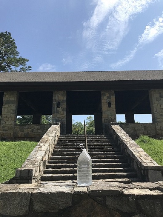
Indian Springs, Flovilla, GA (photo by Hannah Palmer)
“It’s the sweetest water you’ll ever taste,” a woman told me. She made the pilgrimage from Jonesboro every weekend. Her grandsons toted the water back to her car.
“This is all we drink,” said a middle-aged man with tall socks and a hand truck. His wife attended a large jug at the spring. Gout, arthritis, indigestion, kidney function. They told me the sulfurous water was a cure-all.
“You can just buy a gallon in the gift shop,” I joked. Everyone preferred to wait. People had been lining up for this water for hundreds of years, the journey and anticipation part of its healing power. I loved that it remained free for all, and that everyone treated the rules as a quaint suggestion.
Curious and thirsty, I emptied the water bottle intended for my dog and took my turn at the pipe. The plastic frosted instantly with the icy, eggy-smelling water.
“It’s running strong today,” the grandmother commented approvingly.
I had to plug my nose to sip it. The park’s chemical analysis of the water indicated traces of silica, sulfur trioxide, sodium oxide, potassium oxide, lime, magnesium carbonate, ferrous oxide, and manganous oxide, among other minerals picked up during the water’s journey through layers of underground granite.3 These minerals have been shown to aid digestion, so there might be some scientific basis for the water’s purported effects.
What made the springs special was the land. With the first Treaty of Indian Springs the state of Georgia had a piece of paper saying they bought five million acres for $200,000. The treaty also stipulated that some properties be set aside for the Creek treaty signers (who were not unequivocally the tribe’s leaders). The springs, specifically, were to remain in tribal ownership. Understanding that the springs were only as pure as the surrounding land, the treaty carved out “one thousand acres, to be laid off in a square, so as to include the Indian Spring in the centre thereof.”
Eventually Georgia’s government designated this reservation as a public recreation area in perpetuity. What started as a kind of bribe to satisfy McIntosh and his cronies led to the creation of one of the first state parks in the country. It’s an example of how upstream watershed protection contributes to spectacular water quality. There are still 500 acres of unspoiled public land recharging one free and magical little spring.
The Treaty
My boys joined forces with some local kids who knew where to find baby turtles. Immediately after pointing out the “Beware of Slippery Rocks” signs, I slipped and busted my ass in the creek. The phone in my back pocket survived, but my sunglasses disappeared down the rapids. Shorts soaked, I squelched over to the park’s tiny museum with a damp towel wrapped around my waist.
The museum was housed in a stately stone CCC lodge with high timber-framed ceilings and a massive fireplace. A mannequin in Muscogee garb stood in one corner of the display boards that told the springs’ history from the days of Creek ownership to turn-of-the-century spa to a state park. The museum exhibits used the term Muscogee (Creek), following the lead of the modern Muscogee (Creek) Nation of Oklahoma.
Chief McIntosh was everywhere. McIntosh hosted the treaty talks at the famous mineral springs because the central location was accessible to all parties, a halfway point between commercial hubs in Augusta and Oakfuskee Town in present-day Alabama. He also owned the inn where they met and profited from offering it as his own little Mar-a-Lago. Only five miles west of the Ocmulgee River, the national border since 1803, the dignitaries were on McIntosh’s turf, but just barely.
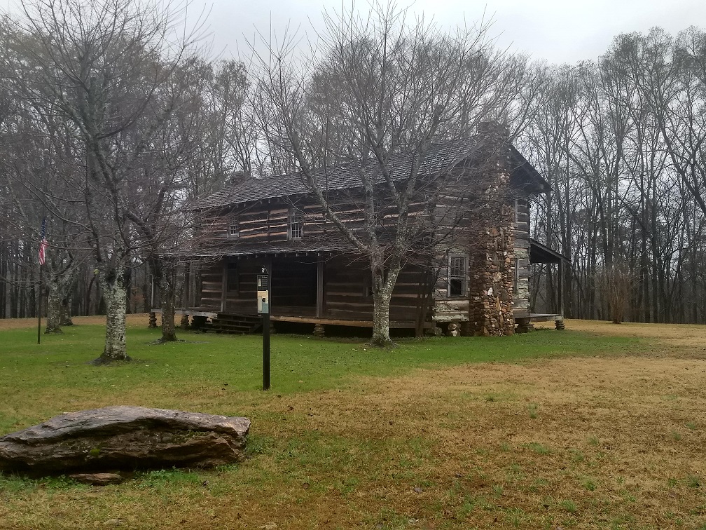
Chief McIntosh’s cabin, Carroll County, GA (photo by Byron Rushing)
McIntosh, a.k.a. Tustunnuggee Hutkee or “White Warrior,” straddled multiple worlds. The son of a Scottish captain and Creek nobility, he was a powerful slave-holding plantation owner who became increasingly corrupt and dependent on treaty payments through his negotiations with the State of Georgia. Historian Michael D. Green called him the “front man in the looting of the Creek Nation.”4
The Muscogee (Creek) treaty signers led by McIntosh did not speak for the entire confederation of Muscogee-speaking peoples, but a faction of the “Lower Creeks,” the cities based along the Flint and Chattahoochee Rivers. (The English came up with those names – Upper and Lower – which, like the term Indian does not exactly correspond to geography.) Facing pressure from the east as their tribal hunting grounds were occupied by armed squatters and settlers, the Lower Creeks were desperate to establish a new border with Georgia. But the Upper/Alabama Creeks supported no further land cessions. This split in the Creek National Council was part of what made the treaty fraudulent.
When McIntosh signed a second Treaty of Indian Springs in 1825, the Creek National Council deliberated for a couple months before ordering his execution. No mere lynch mob, a hundred and fifty Creek soldiers from ceded territory organized a police force called the “law menders.” They surrounded McIntosh’s plantation on the Chattahoochee River and set the buildings on fire. As the traitor fled his house, they stabbed him in the heart. I grew up learning about Chief McIntosh, but somehow missed this striking detail about his violent end.
Names
I stopped by a 1980s photo of dozens of tourists sliding along those timeless rocks. “Cooling off in the historic Hopeothyeloho Creek!” it said. So that’s where I lost my sunglasses. Knowing I would never remember how to spell that word, I took a photo of the caption.
Later, when I came across that name again on a roadside historical marker outside the McIntosh House, I was surprised to learn that the dissenting Upper/Alabama Creeks protested at the talks at Indian Springs. “Hopothleyoholo, orator of the Alabama Creeks, denounced the signers as traitors in a speech delivered from a boulder near the house.” Across the street was a sign for “Big Sandy Creek,” right next to a boulder.
Why wasn’t it called Hopothleyohlo Creek anymore? Meanwhile, the disgraced name of McIntosh remained on the lake, his wealth still on display at the Indian Springs Inn, the park itself held up as the winnings of war. In fact, my cousins claimed to be proud descendants of Chief McIntosh – a claim that I imagine many Northeast Georgia families passed down from generation to generation. I doubt that these claims would hold up to a $99 DNA test, but the myth held a certain power.
On our way home, we looked for lunch in the tiny village of Indian Springs, which is just a crossroads really. We stopped under an old sign for Big Chief Grocery with an old school cigar-store Indian in headdress. It appeared to be closed. Next door was a hip café called Yahola Creek, with a line out the door. A few days later, I figured out that this name was a shortened version of “Opothle Yahola,” the Upper Creek dissenter. These roadside signs were having a public debate over history, over who we remember and what stereotypes need to be phased out. It looked like Yahola was winning.
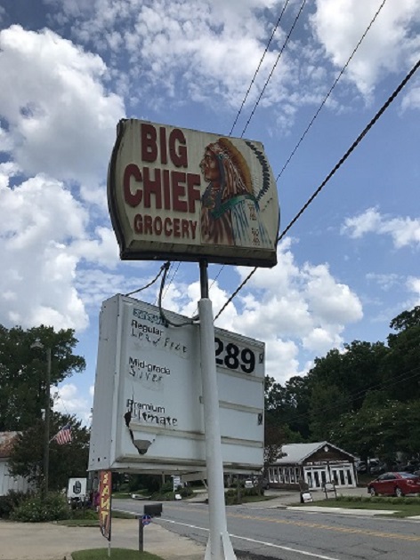
Big Chief Grocery, Flovilla, GA (photo by Hannah Palmer)
The Border
During treaty negotiations, Muscogee (Creek) delegates insisted on a natural boundary. “A dry line will never do between us,” they said.5 And so, the Treaty of Indian Springs established the Flint River as the new edge of Georgia. But did everyone agree on what and where the Flint River was?
Before European explorers, there was probably no single Muscogee word for the 344-mile river we call the Flint River. George Stewart, in Names on the Land, explained that the naming methods of Indigenous peoples were fundamentally different in that “large natural features, such as rivers, were not named as a whole but merely in sections.”6 The Muscogee name for “flint-picking up place” was Hlonotiskahachi, a word that is nearly unpronounceable in English and since been poorly reduced to Thronateeska.7 This name likely only applied to lower sections of the river, where flint was plentiful.
As Georgia’s second longest river, the Flint River is obvious in south Georgia. Upstream at the urban headwaters, the river’s significance is debatable. “Alleged river,” one city worker corrected me, pretty well capturing the skepticism, even contempt I’ve encountered while researching the polluted stormwater channels laced beneath Hartsfield-Jackson Atlanta International Airport.
There are several southside creeks that constitute the Flint’s headwaters, but according to the USGS, a river’s source the farthest distance from its mouth. The Flint River can be traced under the airport all the way up to a tiny but perennial creek in East Point, the very top of the watershed. It starts as a spring which, much like Indian Springs, was marketed as a spa at the turn of the century. Dubbed “Magnesia Springs” and touted for its “splendid waters,” it has since been piped under an industrial district in the crotch of two railroads.
The labels we apply to waters determine how we treat them. “Navigable waterways” are governed by specific agencies. “Wild and scenic” rivers merit special federal protection. In the case of the Flint headwaters, calling a runoff ditch a river affords it some respect if not protections. Then again, christening groundwater seepage with a name like Magnesia Springs carries the precarity of myth making.8 Like claiming native ancestry.
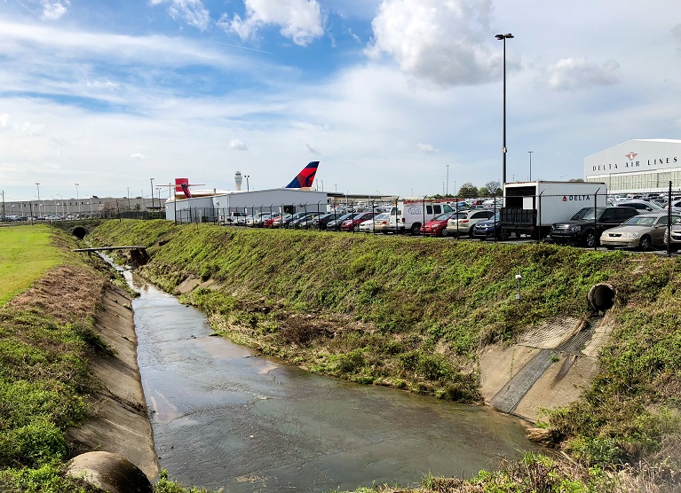
The headwaters of the Flint River at Hartsfield-Jackson Atlanta International Airport, Fulton County, GA (photo by Stacy Funderburke)
The Flint River is so unknown in Atlanta I have often wondered if it suffers from lousy branding. Would it have a better reputation if it had a melodious Muscogee or Cherokee name like so many other southern rivers? I suppose this romantic impulse lies behind the revival of the name Thronateeska in the Albany area. But there’s more downgrading the Flint than its forgettable name. The first 20 miles of the Flint are unmarked, hidden, and contaminated by urban runoff, regarded more as a nuisance than a resource.
The Treaty of Indian Springs sidestepped these headwaters, defining the boundary as, “Beginning on the east bank of Flint river… running thence, up the eastern bank of the same, along the water’s edge, to the head of the principal western branch; from thence, the nearest and a direct line, to the Chatahooche [sic] river…”
This principal western branch was not the river but Line Creek, a large tributary that starts near Fairburn, 12 miles west of the headwaters. Named for its role in the 1821 cession, today Line Creek holds the county line between Fayette and Coweta Counties. With this shortcut to the west, the state seized even more of the prime real estate that would become metro Atlanta. The first large map of Georgia territory, published by Eleazer Early in 1818, noted “these Rivers head in flat Glady Land.”9
Defining the Flint by its western tributary was also a strategic move to separate the Muscogee (Creek) lands from the Cherokees in North Georgia and reduce the possibility of their uniting in resistance to white settlers.10 That’s also part of Atlanta’s DNA – it is a place that was located as a wedge between Indigenous peoples.
The Muscogee (Creek) negotiators insisted on a “wet boundary,” rather than an imaginary line on a map. The fact that Georgia agreed on the Flint River as a political boundary instead of a surveyor’s line seemed like a substantial concession to the Indigenous worldview. A more cynical take is that they agreed because they knew the line would not hold. The river didn’t matter. They were already looking far beyond the Flint.
Riverless City
The Flint River proved flimsy as a national boundary. With the second Treaty of Indian Springs, only four years later, McIntosh signed away all Creek lands west to the Chattahoochee River, effectively extinguishing their claims to territory in modern-day Georgia.
What made it easy to hurdle the Flint River in Georgia’s race for manifest destiny? For one thing, the Flint lacked any major cities between Albany and would-be Atlanta. In the early 19th century, Georgia was defined by its Fall Line cities – Augusta on the Savannah River, Milledgeville on the Oconee, Macon and Okmulgee Old Town on the Ocmulgee River, and Columbus and the Creek capital Coweta on the Chattahoochee. Because of its unique geology, the Flint was and is the only major Georgia river without a city at the Fall Line.
Instead of a city, the Pine Mountain Range rises at the Fall Line, an ancient, twenty-mile ridge that is distinct from the Appalachians but includes the highest southernmost altitudes in the eastern U.S.11 It is disorienting to drive an hour south from Atlanta and find yourself atop Sprewell Bluff with a view of the gauzy Flint winding hundreds of feet below. The river has slowly, steadily cut a course through this rogue mountain range, but the journey has impeded its flow and given the Flint a very different character from Georgia’s other rivers.
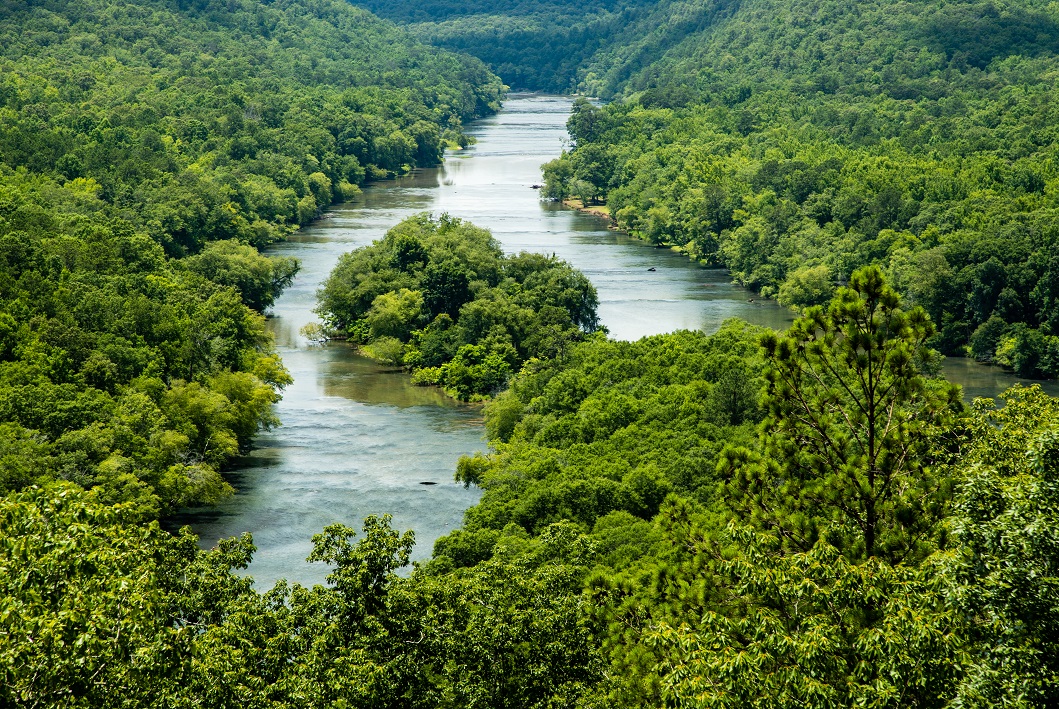
The Flint River from Sprewell Bluff, Upson County, GA (photo by Stacy Funderburke)
The Flint was not dammed for mills at the Fall Line, was never really navigable for steamships that far north. But the river pointed north towards a new kind of city, one not dependent on river navigation or hydropower, that would grow into the capital. All that “flat Glady” land at the headwaters would prove ideal for the railroads of Terminus and eventually, the runways of Hartsfield-Jackson.
This new kind of city was no longer restricted by natural boundaries. Twentieth century Atlanta sprawled in every direction, powered by its transportation network, because no river or mountain could limit its growth.
Tourists like to complain that Atlanta doesn’t have a river. I hear this like it’s a major shortcoming, like Atlanta doesn’t have a soul. Of course, this city has many rivers, but the sentiment holds true. Without public river access in the city it certainly feels like we – most of us anyways – don’t have a river. Instead of arguing this point, I have started to accept that modern Atlanta was designed in defiance of rivers.
The waters that were so valuable to Creek life that Europeans called the people “Muskogee” – a Shawnee term for “swamp” or “wet ground” – were viewed by settlers as an engineering challenge to be conquered with technology – dams, levies, bridges, and culverts.12 The free energy that rivers provide – not to mention the water that every living thing depends on – became a commodity to be harnessed and sold. The rivers, like the Indigenous communities themselves, lay in the way of expansion.
Wet Boundaries
Atlanta was built on stolen land, located to divide people, and engineered to suppress nature. But the resilience of the Flint River suggests what my colleague Chris Lemons told me – “Mother Nature is undefeated.” The river was ignored but never fully erased. In the same subtle way that the Flint River made Atlanta possible, it could remake Atlanta.
If we want quality growth and equity in this city, we could start by honoring wet boundaries. Let stream buffers bridle sprawl – filter pollutants, absorb floodwaters – and let them be publicly accessible. Let rivers and creeks dictate a more sustainable scale for our airports, freeways, convention centers, stadiums, and police training facilities. Future generations could enjoy Atlanta’s urban creeks and springs (which is not that far fetched – visit Austin’s Zilker Park, Denver’s Confluence Park, or Greenville’s Reedy River) if we learned from the structures that creeks can provide to growth.
But the work of reintegrating Atlanta’s natural waterways cannot simply be solved by design and engineering. Atlanta will never be a port city or a Fall Line city with an iconic waterfront. And I can’t picture tubing the Flint River culverts through the airport like you’re in downtown Helen or Boulder.
Sly and spontaneous creek encounters are something I love about this city, an antidote to the placelessness and heat that plagues the urban south. What would Atlanta look like if we protected common greenspace around every spring, deemed each one splendid and sacred? Treated each creek like a tiny museum, playground, and wildlife corridor that it is? Would it help us know who we are, and where?
1821 doesn’t seem that long ago. I think about this whenever I wander through an Atlanta cemetery and scan the headstones for the oldest graves. When I walk my dog down to Utoy Creek and lose sight of the power lines, I can squint my eyes and imagine that the hills and valleys haven’t changed that much in two hundred years. I tell my kids about Muscogee (Creek) hunters stalking deer in these woods, trapping fish in the creeks. This land is water-rich and exploding with life. Our city is so young and undecided.
Hannah Palmer is the author of the award-winning memoir, Flight Path: A Search for Roots beneath the World’s Busiest Airport. She writes about the intersection of southern stories and urban landscapes for venues like Art Papers, Atlanta Magazine, Southern Cultures, and Canopy Atlanta. A graduate of Agnes Scott College, Palmer earned an MFA in Creative Writing from Sewanee: The University of the South. She lives on the southside with her husband and sons.
See more of Hannah’s work at http://HannahSPalmer.com/
CITATIONS:
- “Georgia County Formation Maps.” Rootsweb by Ancestry.com. Retrieved September 2021 from https://sites.rootsweb.com/~gatttp/maps/formationmap.htm
- “Muscogee (Creek) Nation History.” Muscogee Creek Nation. Retrieved September 2021 from https://www.muscogeenation.com/culturehistory/
- Ellington, Sherri. “Historic Waters: State park’s spring remains popular.” The Jackson Press-Argus, July 10, 2017.
- Green, Michael D. The Politics of Indian Removal: Creek Government and Society in Crisis. University of Nebraska Press, 1982.
- Ibid, p. 119.
- Stewart, George R. Names on the Land: A Historical Account of Place-Naming. 1st ed: 1945. Reprint: New York Review of Books, 2008, p. 10.
- Goff, John H. Placenames of Georgia: Essays of John H. Goff. University of Georgia Press, 1975, p. 477.
- Hicks, David W, and Stephen P. Opsahl. “The Natural History of the Flint River,” Sherpa Guides. Retrieved October 2021 from https://www.sherpaguides.com/georgia/flint_river/natural_history/index.html
- “Map of the State of Georgia, Prepared from actual Surveys and other Documents, for Eleazer Early, By Daniel Sturges.” Published Savannah, Georgia, 1818. Retrieved October 2021 from https://digitalarchives.columbusstate.edu/items/show/34
- Green. The Politics of Indian Removal: Creek Government and Society in Crisis. p. 57.
- Hicks and Opsahl. “The Natural History of the Flint River,” Sherpa Guides.
- Hahn, Steven C. The Invention of the Creek Nation 1670-1763. University of Nebraska Press, 2014, p. 243.
Map: “Georgia and Alabama.” Engraved by H. S. Tanner. Source: Georgia Archives; Retrieved November 2021 from: https://vault.georgiaarchives.org/digital/collection/hmf/id/3
Amazing work – there’s so much resonant history and perspective here, it’s hard to know even where to start in lauding Hannah’s efforts in writing this piece. For me as a native Georgian, super eye-opening. By that I mean that I no idea of at least half of this – and the other half was muddy for me. Super illuminating piece.
Thanks for this beautiful piece, Hannah!
All my young life, my mom and dad took us to Indian Springs, this is very interesting, and some good history. Thank you Hannah
Amazing piece, Hannah. Thank you for the insight.
Josh Lumsden